 Travel Guide Travel Guide to the countries of the world

This post is also available in:
![]() Deutsch
Deutsch
CAPE OF GOOD HOPE
The Cape of Good Hope was discovered and doubled for the first time, in 1488, by the Portuguese navigator Bartolomeu Dias. Bartolomeu Dias called it “Cape of the Storms” (or “Cabo Tormentoso”).
The name of Cape of Good Hope (Cabo da Bõa Esperança) was instead given to it by the king of Portugal João II (John II). This name derives from the hopes that its discovery had given to open a new commercial route to reach Asia by sea.
The Cape was again doubled by the Portuguese navigator Vasco da Gama, in 1497. On this occasion Da Gama managed to reach Asia for the first time by circumnavigating Africa.
The Cape of Good Hope (34°21’29 “south and 18°28’19” east), which is located about 30 km from Cape Town, is the southern tip of the Cape Peninsula in South Africa. But it does not represent the southernmost point of the African continent, a record held by Cape Agulhas, which is located about 150 km south-east.
Today the Cape of Good Hope is part of the Table Mountain National Park and together with the Cape Point cliffs it represents the most spectacular area of the nature reserve. There is a wonderful path to be done on foot in less than an hour, which starts from Cape Point and reaches the Cape of Good Hope. The trail runs alongside the high cliffs of Cape Maclear and Diaz Beach.
-

- Diaz Beach, Cape of Good Hope Nature Reserve, Table Mountain National Park, South Africa. Author Marco Ramerini

-

- Cape of Good Hope and Diaz Beach, South Africa. Author Marco Ramerini

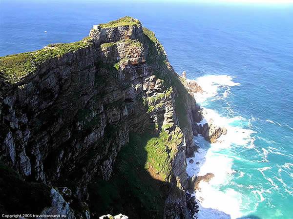
CAPE POINT
Cape Point is a promontory located in the southeastern part of the Cape peninsula, a few hundred meters from the Cape of Good Hope, these two promontories do not represent, as often believed, the southernmost point of Africa. The southernmost point of Africa is in fact Cape Agulhas which is located a few hundred kilometers further south-east.
The Cape Point cliffs are more spectacular and higher than those of the Cape proper. In fact, they reach 240 meters. On the highest point of the promontory is the old lighthouse. This lighthouse was built in 1857 and is connected to the parking area by a funicular and a path. The new lighthouse was installed on the lower promontory.
-

- Cape Point, Cape of Good Hope Nature Reserve, Table Mountain National Park, South Africa. Author Marco Ramerini

-

- Cape Point, Cape of Good Hope Nature Reserve, Table Mountain National Park, South Africa. Author Marco Ramerini.
This post is also available in:
![]() Deutsch
Deutsch


