 Travel Guide Travel Guide to the countries of the world

This post is also available in:
![]() Deutsch
Deutsch
One of the best known and most popular walks in Mount Cook / Aoraki National Park is the one that runs through the Hooker Valley. This trail runs alongside the Hooker River in the shadow of Mount Cook. This walk allows the view of some of the most wonderful landscapes of the Southern Alps and represents one of the best day trips to do in this area of the South Island of New Zealand.
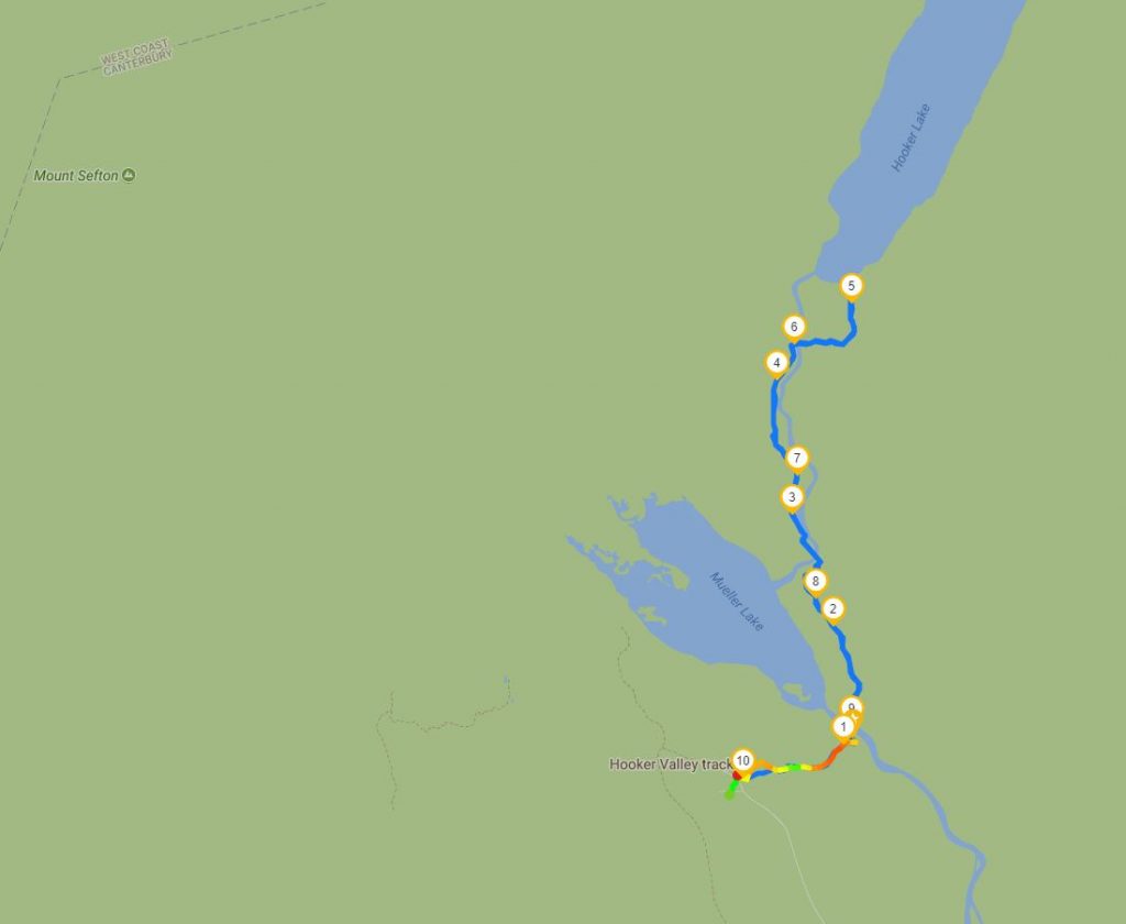
The trail that begins at the end of Hooker Valley Road at the Visitor Center (White Horse Hill campground / carpark) runs through a rugged land of ice and rock along the Hooker River. Along the path you will run alongside the Hooker River and Mueller Lake. The walk ends at Hooker Lake from where you have incredible views of Mount Cook / Aoraki (3,724 meters) and the glacier that descends from New Zealand’s highest mountain. The path is 5 km long (10 km round trip) which takes about 1 hour and 30 minutes / 2 hours (3/4 hour round trip).
Once you have parked your car at White Horse Hill campground / carpark, finding the start of the trail is easy. From the rest area, head north to where the Visitor Center building is located and where the toilets are located. The trail begins a few meters from this structure. A few hundred meters after the start of the trail you pass next to the Alpine Memorial, a monument in memory of the climbers who died in Mount Cook National Park. Shortly afterwards, from above, you can admire Mueller Lake with the Mueller Glacier and the suspension bridge that crosses the Hooker River.
THE HOOKER VALLEY TRACK: A TRAIL AMONG THE NEW ZEALAND ALPS
After crossing the first suspension bridge, the trail follows the glacial moraine of Mueller Lake. Then after just over 1 km you reach another suspension bridge that crosses the Hooker River just before it flows into Mueller Lake. From here the path keeps to the left of the river for 1.6 km up to the third and last suspension bridge giving splendid views of Mount Cook. Part of this section of the path, which runs over a marshy area, is on a wooden walkway.
After crossing the last bridge, the trail climbs along the moraine hill of Hooker Lake for 1 km until reaching the viewpoint on Hooker Lake, the glacier and Mount Cook. The trail ends with an extraordinary view of the Southern Alps, Mount Cook and Hooker Lake. In summer the lake is dotted with icebergs that detach from the glacier that descends from Mount Cook.
If you follow the Hooker Valley Track in late spring – early summer (from mid-November to mid-January) you can observe spectacular blooms of Ranunculus lyallii (Mount Cook buttercup or Mount Cook Lily). This is an endemic flower of New Zealand and which grows only in the South Island and in the Stewart island at an altitude between 700 and 1,500 meters. This species of buttercup is considered to be one of the most beautiful species of buttercups in the world.
This post is also available in:
![]() Deutsch
Deutsch


