This post is also available in:
![]() Deutsch
Deutsch
Namibia (Republic of Namibia) is a presidential republic of Southern Africa, washed to the west by the Atlantic Ocean, bordered to the north by Angola, to the north-east by Zambia and Zimbabwe, to the east by Botswana and to the south-east and south by the Republic of South Africa.
Namibia used to be a German colony and was later administered by South Africa. The capital of Namibia is Windhoek. The country has one the world’s lowest population densities, which amounts to 3,2 inhabitants per square km as of 2018.
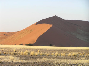
The coast of the Atlantic Ocean, which extends to a length of more than 1,500 km from the mouth of the Cunene in the north to the Orange River to the south, has a sandy lowland formed by the Namib desert, which stretches inland for a depth of over 100 km.
A SERIES OF DESERTIC HIGHLANDS
The central part of the country consists of a series of arid plateaus with heights between 1,000 and 2,000 metres of altitude, which slope down toward the depression of Etosha Pan to the north, to the Kalahari Desert to the east, to the Orange River to the south and to the Namib Desert and the coast of the Atlantic Ocean to the west. The central plateau in some places exceeds 2,000 metres, reaching the highest elevation by the Brandberg mountain with 2,606 metres, the highest peak of the country.
The other major area of the country is made up of the Kalahari desert, located to the east along the borders with Botswana and South Africa. This is a highland characterized by wide sand stretches alternated with scrubs. The main rivers of Namibia are all at the border of the country: to the south is the Orange river, which marks the border with South Africa, to the north along the border with Angola are the Cunene and the Okavango rivers, while the Zambezi marks a brief stretch of the border with Zambia.
A COUNTRY WITH LARGE MINERAL RESOURCES
From the economic point of view the country is rich in mineral resources especially diamonds. There are large quantities of uranium, gold, copper, tin, zinc, manganese, lead, cadmium, vanadium, silver, salt and phosphate. The breeding of cattle, sheep (karakul sheep), goats and poultry is worth mentioning. Another important economic resource is fishing, of which Namibia occupies one of the first places among African states. Thanks to the cold Benguela current Namibian waters are home to some of the richest fishing grounds of the world. Fishing is mainly done for anchovies, sardines and mackerel.
Due to the dry climate agriculture is only extensively developed. Besides cattle grazing maize, millet, sorghum and wheat is cultivated to a modest extent. The industry is scarcely developed. The few industrial enterprises focus on the processing of mineral products, fish and livestock.
TOURISM IS AN IMPORTANT ECONOMIC SOURCE
Tourism is an expanding business and thanks to the amazing desert landscapes eco-tourism is particularly developed. There are many protected areas including national parks like the Etosha N.P., the Namib-Naukluft N.P., the Waterberg Plateau Park, the Fish River Canyon Area as part of the /Ai-/Ais Richtersveld Transfrontier N. P. and the Skeleton Coast N.P.
English text correction by Dietrich Köster.
- Area: 825,418 sq km: arable land 0,8%, pastures 46,1%, forests and woodlands 12,5%, uncultivated and unproductive land 40,6%
- Population: 2,600,000 (as of 2018): Black Africans 84% (Ovambo 50%, Kavango 9%, Herero 7%, Damara 7%, Nama 5%, Caprivian/Lozi 4%, Bushmen/San 3%, Himba 2%, Tswana 0,5%. Additionally people of mixed race 8% (Coloureds, Rehoboth Baster 2%), Whites 7% (Afrikaner 2%, Germans 2%, English and Portuguese-speaking Whites).
- State Capital: Windhoek.
- Languages: The only official language since independence in 1990 is English. Important countrywide languages are Afrikaans and German. Oshiwambo is spoken by half of the population. Other languages are: Herero and Nama.
- Religion: Christians 90% (Lutherans 50%, Roman Catholics 17%, Methodists, Dutch Reformed, Anglicans). Indigenous Beliefs 10%.
- Currency: Namibian Dollar (NAD). The South African Rand (ZAR) is countrywide accepted.
- Time Zone: UTC+1 hour, in summer UTC+2 hours.
This post is also available in:
![]() Deutsch
Deutsch
 Travel Guide Travel Guide to the countries of the world


